

Extraction of metamorphic minerals by multiscale segmentation combined with random forest
-
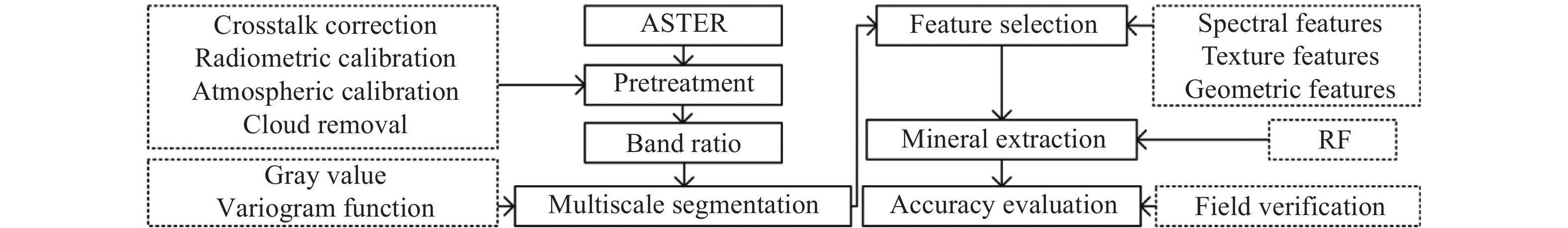
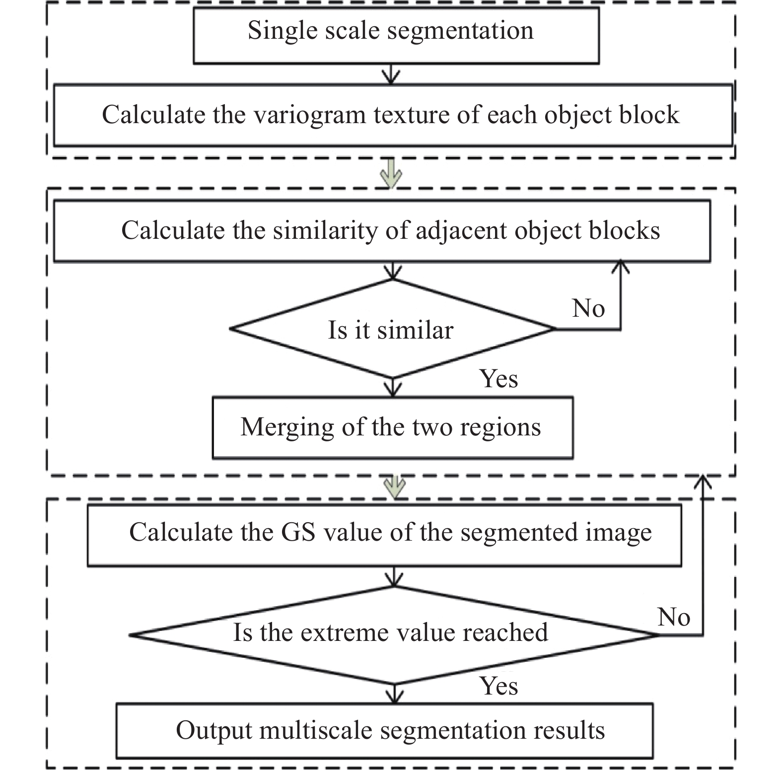
摘要: 為提高遙感影像變質礦物提取精度,提升變質帶的識別效果,以甘肅北山ASTER影像為研究區,結合了比值運算、多尺度分割、隨機森林分類法進行變質礦物提取。首先,通過礦物特征性光譜特征構造比值運算公式、進行影像增強;然后,對增強影像進行基于光譜及變差函數的多尺度分割;接著,采用隨機森林法提取目標礦物;最后,通過野外勘查、采樣、薄片鑒定進行精度評價。結果表明,黑云母、白云母、角閃石在ASTER影像上具有鑒定性特征,提取精度分別為85.4088%、84.7640%和85.7308%;其他含量較少的變質礦物提取精度可達到60%以上。多尺度分割能充分利用礦物的叢集特征;變差函數紋理能增強形態特征對礦物的區分能力;隨機森林分類法對礦物混合引起的噪聲不敏感、提取結果穩定。Abstract: The identification of metamorphic minerals is the basis of metamorphic rock research. Extraction of mineral information by remote sensing technology has been widely used. Digital image processing technology is also effectively applied to remote sensing image processing. Results show that the band ratio of remote sensing images can enhance mineral information, while the variogram function can describe the spatial correlation and variability of image pixels and extract more detailed texture information. The metamorphic minerals are found to present a block or strip distribution. The object-oriented remote sensing image information extraction method can avoid the “salt and pepper phenomenon” based on pixel extraction. Meanwhile, the random forest classification method has a fast calculation speed and high parameter accuracy. It is not sensitive to the noise caused by more lithologic components and its classification effect is found to be stable. To improve the extraction accuracy of metamorphic minerals from remote sensing images and further improve the recognition effect of metamorphic zones, this paper combined the ratio operation, multiscale segmentation, and random forest classification to extract metamorphic mineral information from ASTER images in Beishan area in Gansu Province. Initially, the image was enhanced by the ratio formula of the characteristic spectral structure of the target mineral. Multiscale image segmentation was then performed based on the spectrum and variogram. Finally, the accuracy was evaluated by the thin film identification results of the field exploration samples after the extraction of the target mineral by random forest. Results show that biotite, muscovite, and amphibole have identification characteristics on the ASTER image with an extraction accuracy of 85.4088%, 84.7640%, and 85.7308%, respectively. The extraction accuracy of other metamorphic minerals with less content are found to reach more than 60%. Multiscale segmentation can make full use of the clustering features of minerals and the variogram texture can enhance the ability of morphological features to distinguish the minerals. Random forest is not sensitive to noise and the extraction results are observed to be stable.
-
Key words:
- variogram /
- multiscale segmentation /
- ASTER /
- mineral extraction /
- random forest
-
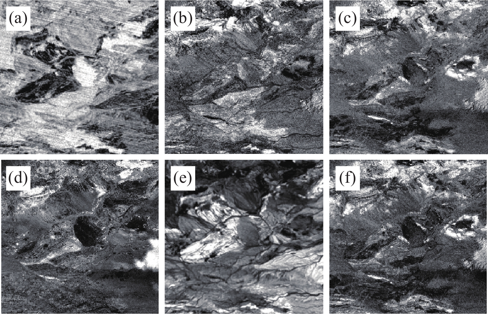
圖 4 比值增強結果。(a)Bi;(b)Mus;(c)Am;(d)Chl;(e)Gt;(f)Act
Figure 4. Ratio enhancement results: (a) Bi; (b) Mus; (c) Am; (d) Chl; (e) Gt; (f) Act
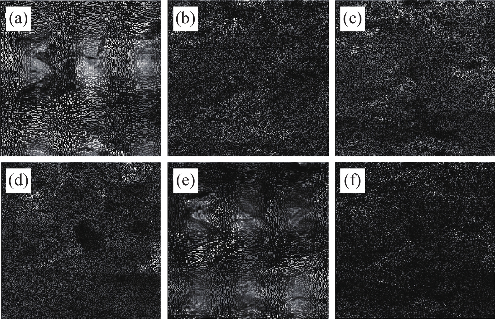
圖 7 多尺度分割結果。(a)Bi;(b)Mus;(c)Am;(d)Chl;(e)Gt;(f)Act
Figure 7. Multiscale segmentation results: (a) Bi; (b) Mus; (c) Am; (d) Chl; (e) Gt; (f) Act
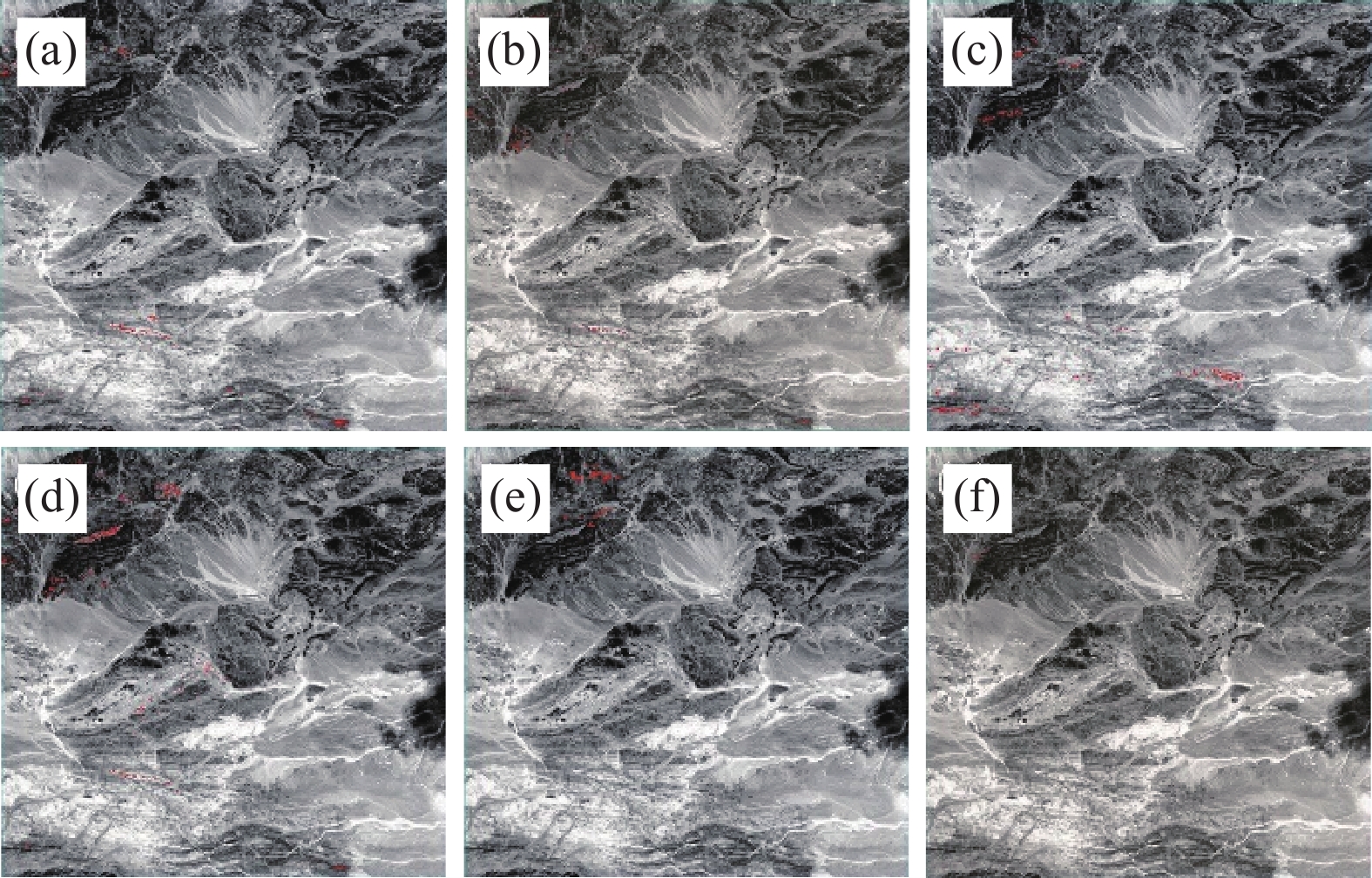
圖 10 礦物提取結果。(a)Bi;(b)Mus;(c)Am;(d)Chl;(e)Gt;(f)Act
Figure 10. Mineral extraction results: (a) Bi; (b) Mus; (c) Am; (d) Chl; (e) Gt; and (f) Act
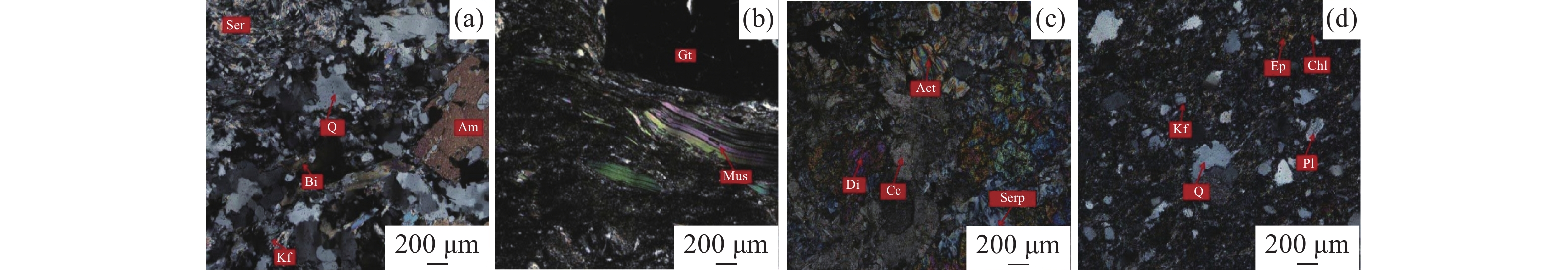
圖 11 部分樣品顯微照片。(a)云母石英片巖;(b)石榴石白云母斜長片麻巖;(c)蛇紋石透輝石白云質大理巖;(d)鈉長石綠泥石石英千枚巖
Figure 11. Micrograph of some samples: (a) mica quartz schist; (b) garnet muscovite plagioclase gneiss; (c) serpentine diopside dolomitic marble; (d) albite chlorite quartz phyllite
Q—Quartz;Pl—Plagioclase;Kf—K-feldspar;Ser—Sericite;Am—Amphibole;Bi—Biotite;Di—Diopside;Act—Actinolite;Serp—Serpentine,Cc—Carbonate minerals;Mus—Muscovite;Gt—Garnet;Chl—Chlorite;Ep—Epidote
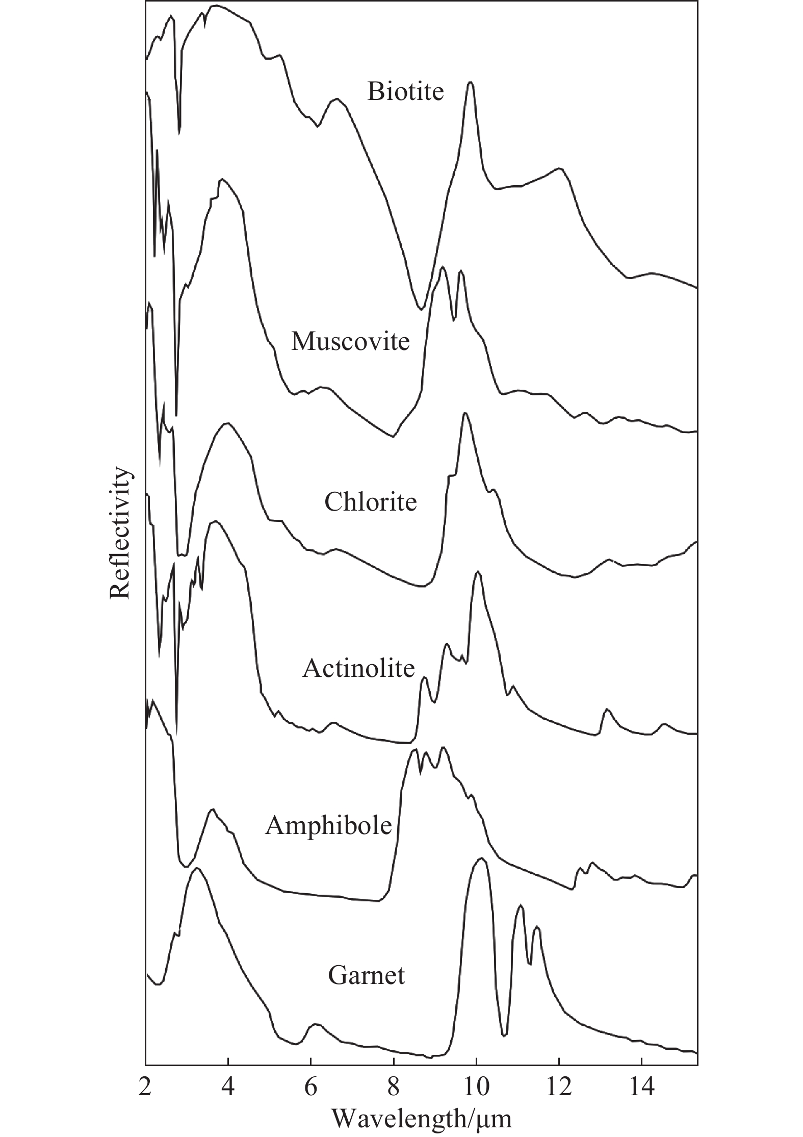
表 1 礦物的吸收譜帶與ASTER波段的對應關系
Table 1. Correspondence relation between the absorption bands of the minerals and ASTER bands
Mineral ASTER band 1 5 6 7 8 9 10 11 12 13 Bi Reflex Absorption Reflex Mus Absorption Reflex Absorption Reflex Am Reflex Absorption Reflex Chl Absorption Reflex Absorption Reflex Gt Absorption Reflex Act Reflex Absorption Reflex  下載: 導出CSV
表 2 各礦物比值公式
Table 2. Ratio formula of minerals
Bi Mus Am Chl Gt Act (b12+b10)/b11 (b5+b7)/b6 (b6+b9)/(b8+b7) (b1+b9)/b8 b13/b12 (b6+ b9)/b8
下載: 導出CSV
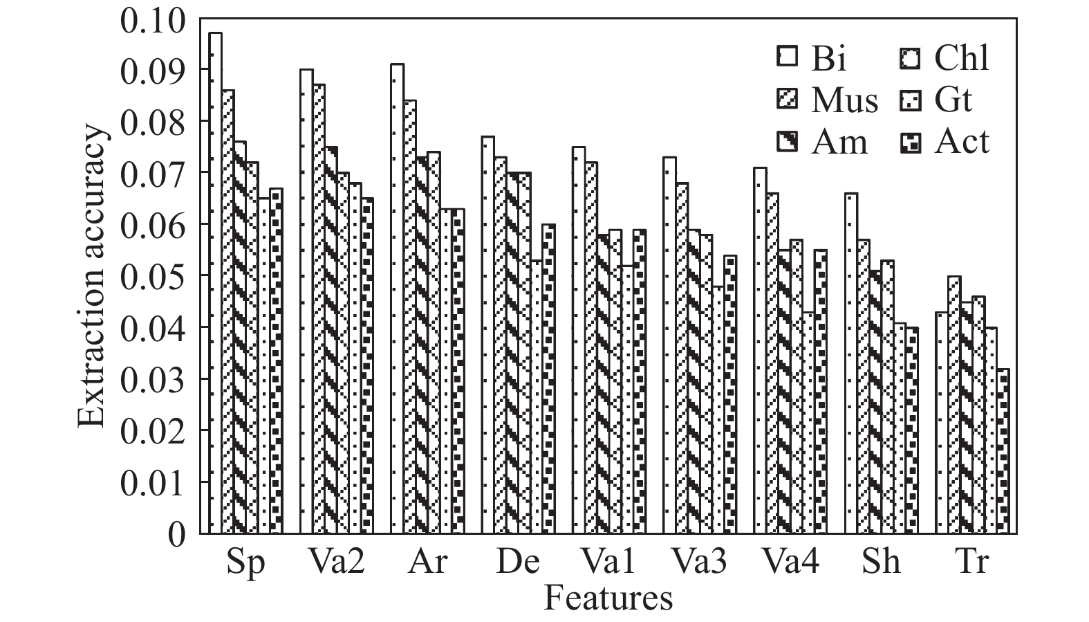
表 4 不同特征數量礦物提取精度
Table 4. Extraction precision of minerals with different characteristic numbers
Features Extraction precision/% Bi Mus Am Chl Gt Act 1 80.0041 75.1212 72.3755 66.0052 64.6564 60.0027 2 82.3421 76.2342 75.1137 67.2311 65.0033 60.0456 3 83.0302 76.7802 76.0232 67.6121 67.9111 60.0101 4 83.0012 76.8767 75.3545 67.5689 65.5889 60.01 5 82.4632 76.2069 75.1182 66.7865 65.3421 60.0043 6 81.8795 76.1951 74.1147 66.0011 65.001 59.9876 7 80.789 76.0022 73.2433 65.5045 64.7768 59.3425 8 79.6574 75.5467 72.1389 64.8675 64.3345 59.0001 9 78.6759 74.3452 71.3511 63.7865 62.9976 58.3456
下載: 導出CSV
表 5 部分樣品薄片鑒定結果
Table 5. Identification results of some sample slices
Sample number Sampling location Lithology Mineral composition Longitude Latitude D0158 96°32′13.1″ 41°59′41.4″ Albite epidote chlorite schist Quartz 48%,Feldspar 25%,Chlorite 12%,Epidote 8%,
Biotite 3%,Sphene 3%D0126 96°32′53.1″ 41°59′20.4″ Plagioclase amphibolite Amphibole 75%,Plagioclase 15%,Quartz 5%,Carbonate minerals 4%,Opaque minerals 1% D0123 96°32′56.6″ 41°59′19.5″ Garnet muscovite plagioclase gneiss Muscovite 30%,Feldspar 62%,Quartz 5%,Garnet 3% D0121 96°32′57.6″ 41°59′19.3″ Biotite plagioclase gneiss Quartz 45%,Plagioclase 33%,Biotite 20%,Amphibole 2% D0117 96°33′8.2″ 41°59′17.8″ Biotite plagioclase gneiss Quartz 28%,Plagioclase 25%,Biotite 25%,Chlorite 15%,
K-feldspar 5%,Opaque minerals 2%D0107 96°33′16.8″ 41°59′7.5″ Tonalite Quartz 42%,Feldspar 34%,Biotite 12%,Amphibole 8%,Carbonate minerals 2%,Sericite 2% D0105 96°33′16.6″ 41°59′4″ Garnet biotite plagioclase gneiss Quartz 50%,Feldspar 31%,Biotite 10%,Garnet 5%,
Opaque minerals 3%,Apatite 1%D0103 96°33′16.3″ 41°59′3″ Garnet biotite plagioclase gneiss Quartz 40%,Plagioclase 30%,K-feldspar 7%,Biotite 12%,Garnet 3% D1125 96°31′36.8″ 41°57′24.3″ Serpentine diopside dolomitic marble Calcite 49%,Diopside 32%,Serpentine 14%,Actinolite 5% D0901 96°40′47.7″ 41°55′39.2″ Albite chlorite quartz phyllite Quartz 32%,Plagioclase 16%,Chlorite 48%,Epidote 4%,Sphene D0420 96°34′35.6″ 41°52′36.5″ Plagioclase amphibolite Plagioclase 55%,Amphibole 30%,Quartz 10%,Biotite 3%,Epidote 2% D0426 96°34′34.5″ 41°52′29″ Mica quartz schist Quartz 50%,Muscovite 30%,Biotite 20% D0450 96°34′14.9″ 41°51′38.6″ Plagioclase hornblende gneiss Plagioclase 35%,Amphibole 55%,Epidote 5%,Quartz 5% D1007 96°30′44.9″ 41°50′45.1″ Mica monzonite gneiss K-feldspar 30%,Plagioclase 25%,Quartz 27%,
Biotite 14%,Muscovite 4%D0055 96°33′49″ 41°50′6.3″ Biotite plagioclase gneiss Plagioclase 38%,Quartz 35%,Biotite 20%,Muscovite 3%,Chlorite 4% D0113 96°34′19.3″ 41°51′46″ Plagioclase hornblende gneiss Amphibole 45%,Albite 37%,Microcline 10%,Quartz 5%,Pyroxene 2%,Opaque minerals 1%
下載: 導出CSV
表 6 精度評價
Table 6. Accuracy evaluation
Mineral PA/% UA/% OA/% Kappa Bi 80.95 78.64 85.4088 0.7779 Mus 83.35 75.60 84.7640 0.7833 Am 79.74 77.55 85.7308 0.7748 Chl 68.74 63.76 70.6933 0.5938 Gt 58.42 58.43 65.5992 0.5462 Act 59.61 64.41 66.7509 0.5560
下載: 導出CSV
中文字幕在线观看表 7 本文方法與其他方法提取精度對比
Table 7. Comparison of extraction accuracy between the present method and other methods
Mineral Extraction accuracy/% Ratio + threshold
segmentationRatio +SVM Method of
this paperBi 77.3546 81.1341 85.4088 Mus 81.2830 82.9870 84.7640 Am 76.9684 81.1002 85.7308 Chl 64.6594 66.4532 70.6933 Gt 61.8422 63.1886 65.5992 Act 62.7847 64.2351 66.7509
下載: 導出CSV
-
參考文獻
[1] Diener J F A, White R W, Link K, et al. Clockwise, low-P metamorphism of the Aus qranulite terrain, southern Namibia, during the Mesoproterozoic Namaqua Oroqeny. Precambrian Res, 2013, 224: 629 doi: 10.1016/j.precamres.2012.11.009 [2] Xie M H, Zhang Q, Chen S B, et al. Extraction of alteration anomaly information by feature-based principal component analysis from ASTER data. Editorial Committe Earth Sci J China Univ Geosci, 2015, 40(8): 1381謝明輝, 張奇, 陳圣波, 等. 基于特征導向主成分分析遙感蝕變異常提取方法. 地球科學—中國地質大學學報, 2015, 40(8):1381 [3] Zadeh M H, Tangestani M H, Roldan F V, et al. Sub-pixel mineral mapping of a porphyry copper belt using EO-1 Hyperion data. Adv Space Res, 2014, 53(3): 440 doi: 10.1016/j.asr.2013.11.029 [4] Wu Z C, Ye F W, Guo F S, et al. A review on application of techniques of principle component analysis on extracting alteration information of remote sensing. J Geo-Inf Sci, 2018, 20(11): 1644 doi: 10.12082/dqxxkx.2018.180195吳志春, 葉發旺, 郭福生, 等. 主成分分析技術在遙感蝕變信息提取中的應用研究綜述. 地球信息科學學報, 2018, 20(11):1644 doi: 10.12082/dqxxkx.2018.180195 [5] Liu Y Z, Lai H R, Zhang D W, et al. Change detection of high resolution remote sensing image alteration based on multi-feature mixed kernel SVM model. Remote Sens Land Resour, 2019, 31(1): 16劉義志, 賴華榮, 張丁旺, 等. 多特征混合核 SVM 模型的遙感影像變化檢測. 國土資源遙感, 2019, 31(1):16 [6] He Z H, He B B. Weight spectral angle mapper (WSAM) method for hyperspectral mineral mapping. Spectrosc Spectr Anal, 2011, 31(8): 2200 doi: 10.3964/j.issn.1000-0593(2011)08-2200-05何中海, 何彬彬. 基于權重光譜角制圖的高光譜礦物填圖方法. 光譜學與光譜分析, 2011, 31(8):2200 doi: 10.3964/j.issn.1000-0593(2011)08-2200-05 [7] Kaur S, Bansal R K, Mittal M, et al. Mixed pixel decomposition based on extended fuzzy clustering for single spectral value remote sensing images. J Indian Soc Remote Sens, 2019, 47(3): 427 doi: 10.1007/s12524-019-00946-2 [8] Feng W Q, Sui H G, Tu J H, et al. Change detection method for high resolution remote sensing images using random forest. Acta Geodaet Cartograph Sin, 2017, 46(11): 1880 doi: 10.11947/j.AGCS.2017.20170074馮文卿, 眭海剛, 涂繼輝, 等. 高分辨率遙感影像的隨機森林變化檢測方法. 測繪學報, 2017, 46(11):1880 doi: 10.11947/j.AGCS.2017.20170074 [9] Booysen R, Zimmermann R, Lorenz S, et al. Towards multiscale and multisource remote sensing mineral exploration using RPAS: a case study in the Lofdal carbonatite-hosted REE deposit, Namibia. Remote Sens, 2019, 11(21): 2500 doi: 10.3390/rs11212500 [10] Cid Y D, Muller H, Platon A, et al. 3D solid texture classification using locally-oriented wavelet transforms. IEEE Trans Image Process, 2017, 26(4): 1899 doi: 10.1109/TIP.2017.2665041 [11] Wang M, Zhang X C, Wang J Y, et al. Forest resource classification based on random forest and object oriented method. Acta Geodaet Cartograph Sin, 2020, 49(2): 235 doi: 10.11947/j.AGCS.2020.20190272王猛, 張新長, 王家耀, 等. 結合隨機森林面向對象的森林資源分類. 測繪學報, 2020, 49(2):235 doi: 10.11947/j.AGCS.2020.20190272 [12] You Y F, Wang S Y, Wang B, et al. Study on hierarchical building extraction from high resolution remote sensing imagery. J Remote Sens, 2019, 23(1): 125游永發, 王思遠, 王斌, 等. 高分辨率遙感影像建筑物分級提取. 遙感學報, 2019, 23(1):125 [13] Li J Y, Zhao Y K, Xue Z E, et al. A survey of model compression for deep neural networks. Chin J Eng, 2019, 41(10): 1229李江昀, 趙義凱, 薛卓爾, 等. 深度神經網絡模型壓縮綜述. 工程科學學報, 2019, 41(10):1229 [14] Cracknell M J, Reading A M. Geological mapping using remote sensing data: A comparison of five machine learning algorithms, their response to variations in the spatial distribution of training data and the use of explicit spatial information. Comput Geosci, 2014, 63: 22 doi: 10.1016/j.cageo.2013.10.008 [15] Harris J. R, He J X, Rainbird R, et al. A comparison of different remotely sensed data for classifying bedrock types in Canada’s arctic: application of the robust classification method and random forests. Geosci Can, 2014, 41(4): 557 [16] Hossain M D, Chen D M. Segmentation for object-based image analysis (OBIA): A review of algorithms and challenges from remote sensing perspective. ISPRS J Photogramm Remote Sens, 2019, 150: 115 doi: 10.1016/j.isprsjprs.2019.02.009 [17] Diaz G F, Ortiz J M, Silva J F, et al. Variogram-based descriptors for comparison and classification of rock texture images. Math Geosci, 2020, 52(4): 451 doi: 10.1007/s11004-019-09833-5 [18] Zhang L, Liu Z, Ren T W, et al. Identification of seed maize fields with high spatial resolution and multiple spectral remote sensing using random forest classifier. Remote Sens, 2020, 12(3): 362 doi: 10.3390/rs12030362 [19] Zhu J J, Fan X T, Du X P. Geometric feature representation and building extraction based on geometric features. J Appl Sci, 2015, 33(1): 9 doi: 10.3969/j.issn.0255-8297.2015.01.002朱俊杰, 范湘濤, 杜小平. 幾何特征表達及基于幾何特征的建筑物提取. 應用科學學報, 2015, 33(1):9 doi: 10.3969/j.issn.0255-8297.2015.01.002 [20] Masoumi F, Eslamkish T, Abkar A A, et al. Integration of spectral, thermal, and textural features of ASTER data using random forests classification for lithological mapping. J Afric Earth Sci, 2017, 129: 445 doi: 10.1016/j.jafrearsci.2017.01.028 [21] Pournamdari M, Hashim M, Pour A B. Spectral transformation of ASTER and Landsat TM bands for lithological mapping of Soghan ophiolite complex, South Iran. Adv Space Res, 2014, 54(4): 694 doi: 10.1016/j.asr.2014.04.022 [22] Zhang B, He B B. Multi-scale segmentation of high-resolution remote sensing image based on improved watershed transformation. J Geo-Inf Sci, 2014, 16(1): 142張博, 何彬彬. 改進的分水嶺變換算法在高分辨率遙感影像多尺度分割中的應用. 地球信息科學學報, 2014, 16(1):142 -

 點擊查看大圖
計量
- 文章訪問數: 761
- HTML全文瀏覽量: 459
- PDF下載量: 27
- 被引次數: 0
